Prime Minister Vajpayee went to China in June. Everyone applauded; Nehru's dream, true Hindi-Chini Bhai-Bhai would finally manifest itself they felt.
The prime minister went to Bali this month. Again, the MEA was jubilant; Foreign Secretary Sibal proudly announced that China had deleted Sikkim from the list of independent states.
Asked if India had raised the Chinese intrusion into Arunachal Pradesh with the Chinese leadership in Bali, Sibal replied in the negative.
Indeed, everything is not hunky-dory between India and China; there is more than what meets the eye behind the current generous Chinese gesture.
Traditionally in China people respect their emperor when he undertakes grandiose projects that no human mind can conceive of. Since 1949, successive emperors have all undertaken such massive projects; the last one was the Three Gorges Dam initiated by then Chinese premier Li Peng. Today, as Hu Jintao and the Fourth Generation takes over China, an even more colossal project is lying on the design table: South-North water diversion.
In September 2001, Associated Press commented: 'The sheer scale harkens back to the mega projects of imperial China and the heyday of Communist central planning. But even in the home of the 1,500-mile Great Wall, the scheme is raising eyebrows. Some question if such a gargantuan project is needed or even wise.'
But the new emperors will go ahead. India could have sat back and watched with amazement the progress of this mega project except for the fact that one of the three components (the western route) of the water diversion will seriously affect the interests of India and Bangladesh.
What is the rationale for the project?
Two of the most acute problems China faces today are food and water. These two issues are closely linked and, if not solved, are bound to have grave social and political consequences for the country.
The leadership in Beijing has proclaimed 'China can feed itself in the next century,' but the fact that the problem is often discussed at the highest level of the Chinese hierarchy shows it is not solved. The new emperors are not sure where the solution lies or even if there is a solution.
A few years ago, Lester Brown, the famous agronomist, advanced a theory: With the growth in China's population (predicted to reach 1.6 billion in 2045) and the increase in industrial development, arable lands reduce rapidly while the needs of population increase simultaneously. With water becoming a rare commodity and agriculture needing more water to sustain production, China has a problem. Moreover, the blue gold is not equally distributed in the Middle Kingdom. Brown's World Watch Institute explains: 'Hydrologically, there are two Chinas -- the humid south, which includes the Yangtze River basin and everything south of it, and the north, which includes all the country north of the Yangtze basin. The south, with 700 million people, has one third of the nation's cropland and four fifths of its water. The north, with 550 million people, has two thirds of the cropland and one fifth of the water. The water per hectare of cropland in the north is one eighth that of the south.'
The fact that the Chinese government published a White Paper titled 'The Grain Issue in China' shows the issue's vital importance for Beijing's leadership.
 This led Chinese experts to look around for water. The answer was not far. The Tibetan plateau is the principal watershed in Asia and the source of its 10 major rivers, including the Brahmaputra (or Yarlung Tsangpo in Tibet), the Sutlej and the Indus. About 90% of the Tibetan rivers' runoff flows downstream to China, India, Bangladesh, Nepal, Pakistan, Thailand, Myanmar, Laos, Cambodia and Vietnam.
The idea to divert the waters from the South to the North was born.
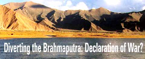
The scheme has three segments: the eastern, central and western routes. The third is the trickiest; it is the one which should make India and Bangladesh nervous. The southern part of the western route envisages the diversion of the Yarlung Tsangpo which will have an immense bearing on the lives of millions in the sub-continent. Originating from a glacier near Mount Kailash, it is the largest river on the Tibetan plateau and the highest on earth. It runs 2,057 kilometers in Tibet before flowing into India, where it becomes the Brahmaputra. One of its interesting characteristics is a sharp U turn (known as the Great Bend) near the Indian border.
It has been discovered recently that the river's gorge forms the longest and deepest canyon in the world. It is in the Great Bend that China is planning one of the most important projects of the diversion scheme. There are two parts: One is the construction of the world's largest hydroelectric plant on the Great Bend dwarfing all other similar projects (it will generate 40,000 megawatts, more than twice the electricity produced by the Three Gorges Dam); the second is the diversion of the waters of the Tsangpo which will be pumped northward across hundreds of kilometers of mountainous region to China's northwestern provinces of Xinjiang and Gansu.
The Tibetans consider the area around the Great Bend, one of the last pristine regions of the world, the home of the Goddess Dorjee Pagmo, Tibet's Protecting Deity. They believe this site, locally known as Pemakö, is the sacred realm often referred to in their scriptures: a last hidden Shangrila.
For South Asia and more particularly for India, the enormity of the scheme and its closeness to the Indian border cannot be ignored. It is not only the sheer size of the project which has to be considered, but the fact that, if accomplished, it will have ominous consequences for millions of people downstream. Ismail Serageldin, a former senior vice-president of the World Bank, once wrote: 'The next World War will be over water.' China's green light for the project could indeed be considered a declaration of war by South Asia.
The project was first reported in Scientific American in June 1996. This article giving credence to the Chinese plans stated: 'Recently some Chinese engineers proposed diverting water into this arid area [Gobi Desert] from the mighty Brahmaputra River, which skirts China's southern border before dipping into India and Bangladesh. Such a feat would be impossible with conventional methods, engineers stated at a meeting held last December at the Chinese Academy of Engineering Physics in Beijing. But they added, "we can certainly accomplish this project" with nuclear explosives.'
The Journal continued: 'This statement is just one of the many lately in which Chinese technologists and officials have touted the potential of nuclear blasts for carrying out non-military goals.'
One of the reasons for China's refusal to ratify the CTBT could be the desire to keep open the option of experimenting with what is called PNE (Peaceful Nuclear Explosion).
In January 1998, the German television channel ZDF presented a feature on the Yarlung Tsangpo project in a program titled Die Welt [The World]. Its chief planner Professor Chen Chuanyu described the plan to drill a 15 km (9.3 miles) tunnel through the Himalayas to divert the water before the U turn and direct it to the other end of the bend. This would shorten the approximately 3,000 meters altitude drop, from 200 km to just 15 km. He explained that the hydropower potential could be used to pump water to Northwest China over 800 km away.
An complicating aspect is that this area had never been visited by outsiders. The difficult access to this unexplored region must have been one of the greatest obstacles for the engineers in Beijing. At the end of the 1990s, the Chinese government decided to permit foreigners to explore the Grand Canyon. A National Geographic expedition, with ultra sophisticated materials and highly professional rafters, made the first discoveries. The opening of this area to adventure tourism was certainly the first step to find an approach route to the dam site.
In recent years, the Chinese have been more discreet about the project although a few reports have continued to come in. The correspondent of The Telegraph in Beijing wrote in October 2000: 'Chinese leaders are drawing up plans to use nuclear explosions, in breach of the international test-ban treaty, to blast a tunnel through the Himalayas for the world's biggest hydroelectric plant.'
The construction of this multi-billion dollar project is tentatively scheduled to begin in 2009. The consequences of a huge storage dam on the Yarlung Tsangpo and the diversion of the waters to northwestern China are multiple and far reaching for Tibet, India and Bangladesh. Most importantly, this project represents a direct threat to the people living downstream.
Let us first look at the dam.
India and Bangladesh would be at the mercy of China for adequate release of water during the dry season, and for protection from floods during the rainy season. India knows from its internal problems how difficult it is to solve a water dispute. When it comes to a transboundary question (where the boundary is not even agreed upon), it seems practically impossible to find a workable understanding.
Precipitation in North India (particularly Assam) and Bangladesh is very high (80%) during the four monsoon months (between June to September) and low (20%) during the remaining eight months. China, for her own interests, could withhold water for power generation and irrigation during the dry season and release water during the flood season with catastrophic consequences for eastern South Asia.
An event in June 2000 could be a small illustration of what may happen on a much bigger scale if the Tsangpo project is completed. At that time, the breach of a natural dam in Tibet led to severe floods and left over a hundred people dead or missing in Arunachal Pradesh. Obviously areas downstream in Arunachal or Assam are extremely vulnerable to what takes place upstream in Tibet.
The massive diversion of the river to China's northwest would have even more devastating consequences. North India and Bangladesh would be starved of their life line. Nutrient-rich sediments that enrich the soil of these regions would be held back in the reservoir instead of reaching the river's delta. Millions would be affected. A water war could ensue.
Another aspect to be considered is once a project is on the drawing board in China, it has to be executed. Whatever the consequences, the leaders in Beijing do not like to lose face.
There is also the competition angle. Beijing knows about the Vajpayee government's project to link most of the Indian rivers during the next 10 years. The Chinese certainly would not like to be seen as lagging behind their southern neighbour in grandiose schemes. If the Tsangpo project is implemented, large parts of the scheme of linking the Indian rivers would become redundant.
Last and perhaps most serious: The Great Bend is located in a highly earthquake prone area. A huge reservoir and a few NEPs could provoke new earthquakes even more devastating than in August 1950 when thousands died. Will men be wise to learn from the past and study Nature's limits and reactions before wanting to alter her? One has doubts.
This raises another important question: Why did Beijing chose Vajpayee's visit to kindle the most sensitive issue of the Sino-Indian relationship (the Chinese claims on Arunachal)?
One can presume that the Arunachal announcement was a diplomatic diversion to hide a far more serious matter for India: the Tsangpo project. On July 17, the People's Daily published a small item: 'China to Conduct Feasibility Study on Hydropower Project in Tibet.' It ran thus: 'China plans to conduct a feasibility study in October on the construction of a major hydropower project on the Yarlung Zangbo River in the Tibet Autonomous Region. An expert team [was sent] to the area for preliminary work between late June and early July.'
The cat was out of the bag though very few people noticed it.
It is clear these questions not only pertain to the environment but also to national and international security. If Beijing goes ahead with the Tsangpo project it would practically mean a declaration of war against South Asia.
The only solution seems to lie in bringing the matter to the negotiating table. If a river waters treaty could be signed between India and Pakistan in the early sixties, why can't a similar agreement be made between China, India and Bangladesh in order to assure a decent life for all in the region?
But do the bureaucrats and politicians even want to know about the problem?
Design: Uday Kuckian